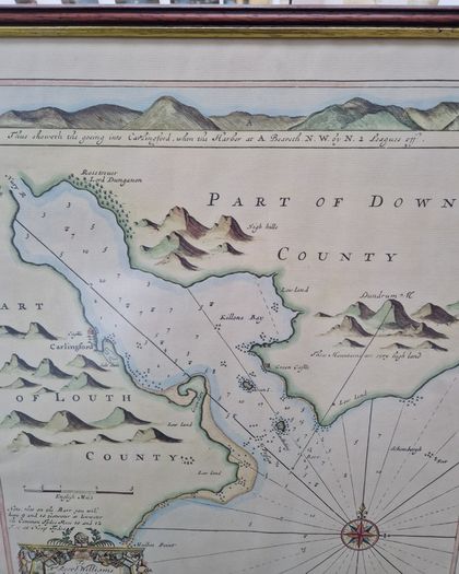
Framed Print Carlingford Lough Navigation

Asking price:
€95
Make an offer:
- Seller:
-
sandmanx
Top Seller

- Feedback:
- Location:
- 77 more ads from this seller
- Entered/Renewed:
- 1 month ago
- Ad Views:
- 156


Viewing
1
of
7
Framed Print Carlingford Lough Navigation
Framed Print Carlingford Lough Navigation
Description
A high quality framed print of original 1693 navigation map of Carlingford Lough. 49 x 62cm framed size behind non-reflecting glass.
Collect Dublin Rd Drogheda. Posting possible at buyer's risk.
The map is titled "A Chart of Carlingford Lough" and was published as part of Collins' atlas, Great Britain's Coasting Pilot, first released in 1693.
Collins spent seven years surveying the British coasts for this atlas, which was the first original sea atlas produced by an Englishman.
The chart includes a coastal recognition profile of the entrance to the Lough to aid sailors in identifying the coastline.
B35
Shipping: Collection Post/CourierTo be arranged
Post/CourierTo be arranged
Payment: To be arranged
From sellers around the web:
Comments & Offers
Asking Price: €95  No swaps
Ask Question
Make Offer
See more in our Pictures & Paintings category available today

€20.00 
€25.00

€20.00

€25.00

€10.00

€10.00

€180.00

€9.00

€100.00

€6.00

€15.00

€44.00

€100.00

€100.00

€10.00
€30.00

€10.00

€290.00

€10.00

€15.00